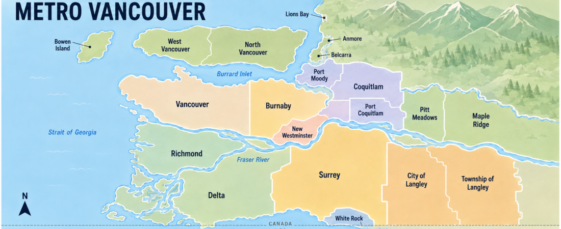
Metro Vancouver offers dense downtown neighbourhoods, suburban town centres, waterfront communities and mountain access within one region. That variety is useful, but it can also make choosing a home complicated. Two addresses described casually as “Vancouver” may have very different rents, school districts and commuting conditions.
The City of Vancouver is only one municipality. Metro Vancouver is both the common name for the wider region and a regional federation that provides services such as drinking water, wastewater treatment, solid-waste planning, air-quality management and regional parks.
Metro Vancouver consists of 21 municipalities, one electoral area and one treaty First Nation. This distinction matters when comparing housing, employment, schools, transportation and attractions.
Population figures in this guide come from Metro Vancouver’s 2024 population projections. These are estimates rather than 2021 Census counts. Adding the populations of all 23 member jurisdictions produces a regional population of approximately 3.12 million residents.
Metro Vancouver at a Glance
Metro Vancouver is located in southwestern British Columbia on Canada’s Pacific coast. The region is shaped by Burrard Inlet, the Fraser River, the North Shore mountains and the nearby Canada–United States border.
Vancouver International Airport is located in Richmond rather than the City of Vancouver. Major BC Ferries routes leave from Tsawwassen in Delta and Horseshoe Bay in West Vancouver.
Newcomers and international students are attracted by educational opportunities, employment, cultural diversity and access to nature. Families can choose among urban, suburban and lower-density communities, while visitors can combine city attractions with beaches, forests and mountains.
The region also presents significant challenges. Housing costs are high, suitable rental homes can be competitive and cross-region commuting may take much longer than expected. Traffic around bridges and major highways can change quickly.
| Area | 2024 population | General character | Transportation | Relative housing cost | Often suitable for |
|---|---|---|---|---|---|
| Vancouver | 757,849 | Dense, urban and walkable in central areas | Three SkyTrain lines, buses and cycling | Generally among the highest | Urban professionals, students and car-free households |
| Surrey | 700,602 | Large, fast-growing and highly varied | Expo Line, RapidBus and buses | Varies widely; often lower than Vancouver | Families, workers and households wanting more housing choices |
| Burnaby | 298,986 | Central, urban and transit-oriented | Expo and Millennium lines | Generally high near major centres | Commuters and students |
| Richmond | 242,966 | Flat, multicultural and airport-adjacent | Canada Line and buses | Generally high; varies by neighbourhood | Airport workers and transit users |
| Tri-Cities | 282,561 combined | Suburban centres near forests and mountains | Millennium Line, buses and West Coast Express | Moderate to high by regional standards | Families and outdoor-oriented residents |
| North Shore | 222,544 combined | Mountain and waterfront communities | SeaBus, buses and bridges | Generally high to very high | Outdoor enthusiasts and established households |
| Langley | 198,242 combined | Growing suburban and semi-rural communities | Buses; driving remains important | Varies; potentially more space for the cost | Families and car-owning households |
| New Westminster | 92,433 | Compact, historic and centrally located | Expo Line and buses | Moderate to high by regional standards | Transit commuters and apartment residents |
| Delta | 125,175 | Three distinct suburban communities | Buses, highways and ferry access | Varies by community and housing type | Families, ferry users and suburban households |
| Maple Ridge and Pitt Meadows | 128,181 combined | Lower-density communities close to nature | West Coast Express and buses | Varies; more space may require a longer commute | Families and nature-oriented residents |
Housing descriptions in this table are relative rather than exact price quotations. A newer apartment beside a SkyTrain station may cost more than an older home elsewhere in the same municipality.
Major Cities and Communities in Metro Vancouver
Vancouver — Population 757,849
Vancouver is the region’s largest municipality according to Metro Vancouver’s 2024 projection. It is also the most recognizable urban centre in British Columbia.
Downtown, the West End and neighbourhoods near Broadway offer relatively strong walkability, frequent transit, restaurants and access to major employment areas. The city is served by the Expo, Millennium and Canada SkyTrain lines, although many residential neighbourhoods still depend on buses.
Stanley Park, English Bay, Kitsilano Beach, Granville Island, museums and cultural venues are accessible from central neighbourhoods. Vancouver also has extensive cycling routes, although conditions and comfort levels vary by street.
The University of British Columbia is frequently associated with Vancouver, but its main campus is west of the City of Vancouver boundary in Electoral Area A. Langara College is located within Vancouver. Students should always confirm the exact campus before choosing housing.
Housing is Vancouver’s most significant limitation. Apartments, condominiums and shared homes are generally expensive, while detached homes are outside many household budgets.
Living in a smaller home close to work or school may still make sense if it reduces transportation expenses and eliminates the need for a vehicle. Vancouver may particularly suit residents who value walkability, frequent public transportation and urban services over additional living space.
Burnaby — Population 298,986
Burnaby is located between Vancouver, New Westminster and the Tri-Cities. Its central position makes it one of Metro Vancouver’s most convenient commuting bases.
Metrotown, Brentwood and Lougheed are major town centres containing shopping, restaurants, public services and high-rise housing. The Expo and Millennium SkyTrain lines serve different parts of the city.
Simon Fraser University’s main campus is located on Burnaby Mountain. The main campus of the British Columbia Institute of Technology is also in Burnaby.
The city offers more than urban development. Deer Lake Park, Burnaby Lake and Burnaby Mountain provide trails and outdoor recreation.
Housing ranges from apartments and high-rise condominiums to townhouses and detached homes. Homes close to SkyTrain stations and major town centres can be expensive because of their transportation and shopping convenience.
Burnaby’s hills also affect daily life. A property that appears close to a station on a map may involve a steep walk or an additional bus connection.
Burnaby can suit students, commuters and households that want relatively central access without living in the City of Vancouver. Residents should compare the specific neighbourhood because transportation convenience differs considerably across the city.
Richmond — Population 242,966
Richmond is located mainly on islands in the Fraser River delta. Vancouver International Airport is within Richmond, making the city convenient for aviation and airport-related employment.
The Canada Line connects Richmond city centre and the airport with Vancouver. Neighbourhoods near stations can work well for residents who do not own a car.
Richmond’s relatively flat terrain supports walking and cycling. The city is also known for Asian shopping centres, restaurants, grocery stores and cultural businesses.
Steveston is a historic waterfront community with walking paths, restaurants, fishing-related history and access to the Fraser River. Richmond also has parks, dike trails and recreational facilities.
Housing includes apartments near Canada Line stations, townhouses and detached homes. Costs vary according to location, building age and transportation access.
Richmond is low-lying floodplain land protected by an extensive system of dikes, drainage and flood-management infrastructure. Prospective residents can review the city’s official flood and emergency information without assuming that the entire city is unsafe.
Other practical considerations include airport noise in certain locations, bridge congestion and commuting distance to workplaces outside Richmond.
Surrey — Population 700,602
Surrey is one of Metro Vancouver’s largest and fastest-growing municipalities. It covers a large geographic area and contains distinct communities such as City Centre, Guildford, Fleetwood, Newton, Cloverdale and South Surrey.
A general statement about living in Surrey is incomplete without identifying the specific neighbourhood. Housing, transportation and everyday services differ significantly across the city.
Surrey City Centre has high-rise development, post-secondary facilities, shopping, health-care services and Expo Line access. Other communities are predominantly suburban and may require a vehicle for work, school or shopping.
Surrey offers apartments, townhouses and detached homes. It also has employment in health care, education, construction, retail, transportation and logistics.
The Expo Line currently serves stations in northern Surrey and ends at King George Station. The Surrey–Langley SkyTrain extension is under construction and has an anticipated in-service date in 2029.
Prospective renters and buyers should not calculate today’s commute as if future stations were already operating. Construction schedules and project details can change.
Surrey may suit families and workers who want a wider variety of housing types. However, the exact neighbourhood, workplace and transportation route should be checked carefully.
Coquitlam, Port Coquitlam and Port Moody — Combined Population 282,561
Coquitlam, Port Coquitlam and Port Moody are three separate municipalities collectively known as the Tri-Cities. They are not three neighbourhoods within one city.
The communities share School District 43 and some regional services, but each has its own municipal government and local characteristics.
Coquitlam — Population 174,248
Coquitlam is the largest of the Tri-Cities. Coquitlam Centre, Burquitlam and neighbourhoods along the Millennium Line provide relatively convenient transit access.
Housing includes high-rise apartments, condominiums, townhouses, basement suites and detached homes. Hillside neighbourhoods may require a car or bus connection even when they appear close to a SkyTrain station.
Town Centre Park, Mundy Park and nearby mountain trails make Coquitlam attractive to families and residents who enjoy outdoor activities. Coquitlam Centre and surrounding commercial areas provide major shopping and everyday services.
Port Coquitlam — Population 69,371
Port Coquitlam lies along the Fraser and Pitt rivers. It has a lower-rise, family-oriented character, a walkable downtown and the Traboulay PoCo Trail.
Port Coquitlam does not have a SkyTrain station. Many public-transit trips require a bus connection to Coquitlam Central or another transportation hub.
The city has a West Coast Express station, but this train mainly provides weekday peak-direction commuter service rather than frequent all-day transportation.
Port Coquitlam may suit families who value parks, trails and community facilities. People commuting to Vancouver should calculate the complete journey, including bus transfers and waiting time.
Port Moody — Population 38,942
Port Moody is the smallest Tri-Cities municipality. It is located around Burrard Inlet and combines waterfront areas, hills and residential neighbourhoods.
Moody Centre and Inlet Centre stations provide Millennium Line service. Moody Centre also has West Coast Express service.
Rocky Point Park is one of the community’s best-known attractions, offering waterfront paths, recreation and access to local businesses.
Port Moody’s limited geography and hilly terrain affect housing development and road travel. Traffic bottlenecks can occur on routes connecting the city with Coquitlam, Burnaby and the North Shore.
North Vancouver and West Vancouver — Combined Population 222,544
“North Vancouver” may refer to either the City of North Vancouver or the District of North Vancouver. These are separate municipalities.
City of North Vancouver — Population 67,980
The City of North Vancouver is compact and centres on Lonsdale Avenue. The SeaBus connects Lonsdale Quay directly with Waterfront Station in downtown Vancouver.
Apartments, condominiums, restaurants and everyday services are concentrated around Lower and Central Lonsdale. The city may appeal to people who work downtown but prefer living near North Shore recreation.
Housing is generally expensive, and residents travelling by road remain affected by bridge congestion.
District of North Vancouver — Population 102,284
The District of North Vancouver surrounds much of the city and includes larger residential areas, mountain neighbourhoods and extensive outdoor recreation.
Grouse Mountain, Mount Seymour, Lynn Canyon and numerous trails are accessible from different parts of the district. Some neighbourhoods are well served by buses, while others are more practical with a vehicle.
Snowfall can be greater at higher elevations than near the waterfront. A prospective resident should check elevation, road access and winter transportation.
District of West Vancouver — Population 52,280
West Vancouver is another separate municipality located west of North Vancouver. It includes Ambleside, Dundarave and Horseshoe Bay.
The municipality has waterfront parks, access to Cypress Mountain and a BC Ferries terminal at Horseshoe Bay. Housing is generally expensive, particularly for detached properties.
North Shore road travel depends heavily on the Lions Gate and Ironworkers Memorial bridges. Congestion, collisions and winter weather can significantly affect commuting time.
New Westminster — Population 92,433
New Westminster is a compact city beside the Fraser River. It has historic streets, riverfront paths and several Expo Line stations.
Its central position provides access to Burnaby, Surrey and downtown Vancouver without requiring a car. Apartments and condominiums are common, especially around transit stations.
The city’s small area and older street network can create traffic bottlenecks. Train noise, hills and busy roads may affect certain neighbourhoods.
Prospective residents should visit a potential home during rush hour and in the evening. New Westminster can be a practical option for transit commuters who want an established city centre outside Vancouver.
Delta and Tsawwassen — Population 125,175
Delta contains three notably different communities: North Delta, Ladner and Tsawwassen.
North Delta connects closely with Surrey and consists mainly of suburban residential neighbourhoods. Ladner has a small-town centre near agricultural land and the Fraser River.
Tsawwassen is located near beaches, the United States border and the Tsawwassen ferry terminal. The neighbouring Tsawwassen First Nation, with a projected population of 4,869, is a separate treaty government and Metro Vancouver member.
Delta may appeal to families who prefer suburban communities and access to parks or ferry routes. However, SkyTrain does not currently reach the municipality.
Bus frequency, highway congestion and the distance to work or school should be checked carefully. Delta’s agricultural areas are important parts of the regional food system and should not be viewed simply as empty land awaiting development.
City of Langley and Township of Langley — Combined Population 198,242
The City of Langley and Township of Langley are separate municipalities.
The City of Langley, with a projected population of 35,316, is a compact urban municipality. It contains apartments, shops, restaurants and public services within a relatively small area.
The Township of Langley, with a projected population of 162,926, surrounds much of the city. It includes Walnut Grove, Willoughby, Fort Langley, Aldergrove and significant rural and agricultural land.
Families may find a larger selection of townhouses and detached homes than in central Vancouver. However, many daily trips still depend on driving, and bus service varies considerably.
The Surrey–Langley SkyTrain is expected to reach Langley City Centre in 2029. Until regular service begins, it should be treated as a future transportation benefit rather than current SkyTrain access.
Maple Ridge and Pitt Meadows — Combined Population 128,181
Maple Ridge and Pitt Meadows are located east of the region’s central cities, near rivers, farmland and mountain recreation.
Maple Ridge has a projected population of 106,489, while Pitt Meadows has a projected population of 21,692.
The communities offer suburban neighbourhoods and access to natural areas such as Golden Ears Provincial Park. Larger homes may be available compared with some central locations, although additional space does not automatically mean inexpensive housing.
Both municipalities have West Coast Express stations. The service can be valuable for weekday commuters, but it is less flexible than frequent, all-day SkyTrain service.
Driving times may increase sharply because of bridge traffic, collisions, construction or weather. Commuters should test the actual trip during their expected working hours.
Smaller Metro Vancouver Member Jurisdictions
Metro Vancouver also includes the following smaller jurisdictions:
- White Rock: 25,129
- Electoral Area A: 35,124
- Bowen Island: 4,677
- Anmore: 2,568
- Lions Bay: 1,468
- Belcarra: 704
These communities include a compact seaside city, islands, villages and unincorporated areas. Small population numbers should not be interpreted as meaning that their lifestyles are identical.
Depending on the location, ferry schedules, limited public transportation, wildfire preparation, septic systems or long trips to everyday services may be important considerations.
Choosing a City Is Only the First Step
Population and general character can help narrow a housing search, but they cannot identify the right neighbourhood by themselves.
A large municipality such as Surrey or Coquitlam contains both transit-oriented centres and areas where daily driving is much easier. Even within compact cities, hills, bridge crossings, school catchments and distance from grocery stores can change everyday life.
Compare exact addresses rather than relying only on municipal names. Test the trip to work or school at the time you would normally travel, examine evening and weekend transit and calculate the complete monthly cost.
Part 2 of this guide covers transportation, housing, weather, employment, education and a practical rental checklist.
Information such as population projections, transit projects and housing conditions can change. Readers should confirm current details with the relevant official organization.